Showing posts with label GEOGRAPHY. Show all posts

Monday, June 19, 2017

FINAL SHELF-ASSESMENT

FINAL ASSESMENT

This school year has been amazing I like all the activities that we do I also love the games with Clarissa in witch I learn a lot, Also the geaography classes are so intersting and funny, and I also like P.E but I don't like the strenght exam and stamina because I'm not to much preparated for this types of activities but I think that this year has been amazing and i will remember it for all my live.
THANKS FOR ALL YOUR HELP
 

GEOGRAPHY Unit 7

VOCABULARY
  • Secondary sector: Economic sector that consist of constructions and industry
  • Raw energy: Resource that is transformed into finished or semifinished products by means of an industrial process 
  • Energy source: Natural resource that provides the necessary power to operate machines
  • Capital: Money, buildings and machinery used in industrial production
  •  Finished products: Industrialprooduct used that is ready for comsuption
  • Refining process: Process that extracts derivate like petrol and diesel from oil
  • Strike: Period of the time when workers agree to stop working to get better working conditions

  •  Pyme: Small or medium-sized company with limited number of workers and limited profits 
  • Tide: Regular rising and falling movement of the sea
  •  Concrete: Very hard building material made by mixing small stones, sand, water and cement

GEOGRAPHY Unit 6

VOCABULARY
  • Wheat: The grain of a cereal used in the form of flour
  • Corn: Is a tall cereal plant that grows normally in summer
  •  Barley: A cereal plant of grass family used to make beer and whiskey
  •  Sorghum: Is also a cereal and is used to make syrup
  • Yams: Is the starchy root of an Afrcan climbing vine and is only grow in warm places
  • Avocado: Is a pear-shaped fruit that is green inside and you can eat it
  •  Dates: Is a fruit that is grow in hot places and is sweet
  •  Soybean: the seed of this plant is used for food and livestock
  •  Chickpeas: Is a cultivated plant used in many countries for food
  •  Jute: A strong, rough fiber using for making cordage
  •  Sisal: Is a strong fiber used for making clothes
  •  Sea bass:Resultado de imagen de sea bass

Monday, March 27, 2017

ENGLISH / GEOGRAPHY/ P.E. SELF-ASSESSMENT

SELF-ASSESMENT

This term I learn many things like diference the crime and criminals and also to describe landscapes, also the thing that I like the most are the class that Clarisa give us, I did almost all well but I have to study and pratice to get better in the things that i don't do well, I also not confused about anything, I'm preparing another degree studying with kendbrige, I need to be more constant studying and not to left all for the last day, I learn many thing that occurs in jamaica,  many types of governments and also many famos spots and sportmen from different places of th world.

GEOGRAPHY Unit 5

VOCABULARY 
  • Agricultural Landscape: Is a land that has, over time, been transformed by the farming activities of human beings in order to grow crops and obtain products from nature.
  •  Plot: Is a section of the agricultural landscape and a piece of land which is used for growing crops
  •  Rural Settlements: are where people in the countyside live
  • Agriculture and Livestock: Provide food and raw materials to produce other type of products
  • Mining: Consist of extracting minerals from the earth surface
  • Forestry: Is mainly focused on obtaining wood for construction or for making furniture and paper
  • Fishing: Is the catching and removal of fish or other aquatic species from their enviroment
  • Aquaculture: This tecnique refers to the breeding of aquatic species in underwater farms known as fish farms


    GEOGRAPHY Unit 4

    VOCABULARY 
    • Nation: A group of people who share common custom and origin
    • State: The supreme public power whithin a sovereign political entity
    • Country: A territory distinguished by its people, culture, language, geography, etc
    •  Inhabitant: A person or animal that is apermanent resident of a particular place
    • Citizens: A resident of acity or town, especially one entitled to vote and enjoy other priviledges there
    • Civil servants: Governement workers
    • Taxes: Money that you pay to the state for pay things like sanitation and education
    • Border: The line that divides two countries or areas
    • Law: The whole system of rules that everyone  in a country must obey
    • Autocracy: Is a governement in which one person has all the power
    • Democracy: Is apolitical system in wich the citizens hold the political power
    • Oligarchy: A small group of people has all the power

    Tuesday, March 14, 2017

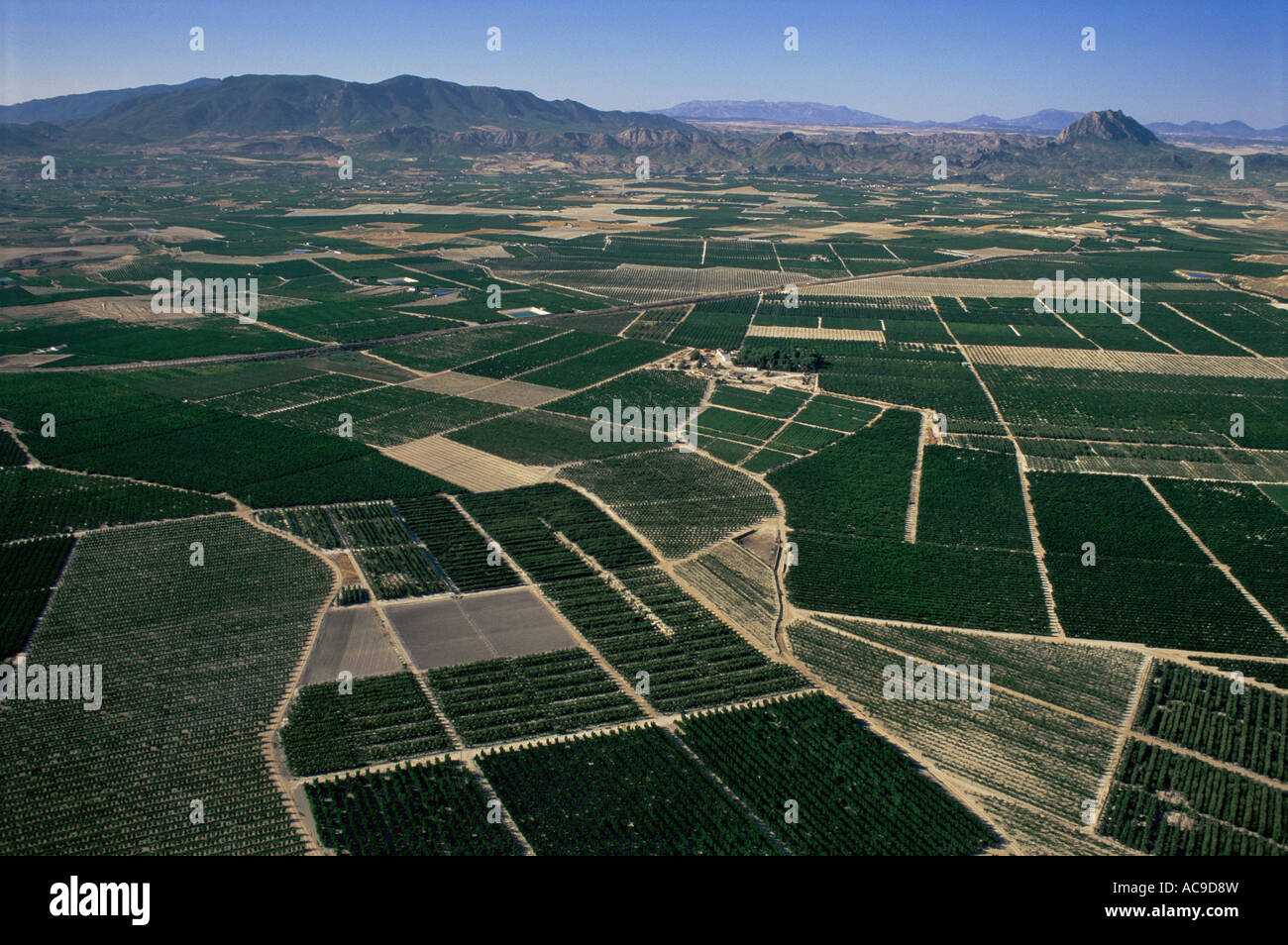
    GEOGRAPHY Agricultural Landscape


    Resultado de imagen de AGRICULTURAL LANDSCAPE SPAINAGRICULTURAL LANDSCAPE
    This picture is a landscape from Jumilla Murcia Spain, this landscape is an agricultural one and here you can see that here are many plots that are enclose and in wich the agriculteur plant the crops, as you can see is an extensive agriculture and also in the most plots of this picture there is a monoculture farming because there is only plant one type of crops and also is a irrigated farming because here in this province of spain the climate and the temperatures are very high and also the precipitations are scarce so the agriculteur normally use irrigation systems to plants stay alive and they can have the production alright, also here there isn't many people for work so normally they use machinery to collect all the products that they plant wich it means that the place is really scarce so the people has to work on they own, Here in this province they normally plant strawberries and vineyards because in spain are two of the more consumated products
     

    Sunday, March 05, 2017

    WORK BY GROUPS

    LINK TO WORK

     http://prezi.com/3pm0sljtqqu5/?utm_campaign=share&utm_medium=copy

    MADE BY ALVARO CALVO, IRENE GOMEZ Y GADEA SERRANO

    Friday, January 13, 2017

    GEOGRAPHY

    Questions of the video 

    Where in the world is Africa? 
    Africa is in the south of Europe and in the south west of Asia

    How many times is Africa larger than The United States?
     Africa is three times the United States

    How is the savanna defined in the video?
     The savanna are the wildest grasslands in Africa and it says that the savanna is a grassy plain that covers nearly a half of Africa The savanna is characterised by scattered trees among a landscapes of grasses and shrubs

    Which animals can be found in the savanna biome?
     You can find giraffes and elephants

    Where is located the chaparral biome in Africa?
     The chaparral biome is found in the northen coast of Africa long the mediterrean and also in the southern coast.

    Which are the most famous deserts in Africa?
    • The Sahara desert
    • The Namib desert 
    • The Kalahari desert 

    The main natural resources mentioned in the video are .....
    • The gold mines
    • The Rove trees
    • The oil
    Find the missing words

    1.      Africa runs 5 000 miles from the Mediterranean sea all the way down to the Good Hope           cape in south Africa  and 4 600 miles from Cape Verde all the way over to Somalia

    2. Biomes are climate zones and throughout that area, throughout that region , you can see the same average temperature and average precipitation what that means is that you also see very similar plants and animals living in that region.


    3.      The most famous desert in Africa is, of course, the Sahara desert. Now, some parts of the Sahara desert are sandy, like you can see here. Other parts of the Sahara desert are rocky but in either case, the fact that it is very dry is going to make it a very difficult barrier to cross.


    4.      It is not the rain itself that’s particularly important, it’s also the biodiversity .There are many different plants and animals species .That can be found in the rain forest   and that’s one of the thing that makes the rain forest so valuable not just in Africa but throughout the Earth. 


    5.      The Nile river is the most famous river in Africa, because is the longest river in the world. But there is also the Congo river which is the naive river in the world.


    6.      Africa actually has its own version of the great lakes with famous lakes like Lake Malawi, lake Victoria and lake Tanganylka


    7.      All the Africa is a plateau. Meaning that Africa itself is an elevated  land. But that doesn’t mean you can’t find any mountains in Africa. You can find mountain ranges like, for example, the Atlas mountains in northwestern Africa.


    8.      Africa also has some interesting mountains like mountain Kilimanjaro , the highest peak in Africa which seems to just rise on it own out of the ground


    9.      The Great Rift Valley refers to a region of Africa that is  literally, being split apart. There are some tectonics plaques that are located within or near Africa, that are, actually, moving away from each other, and what’s doing is creating not just some of the highest elevation in Africa, but also lakes like Tanganylka that is among the deepest in the world.

    Thursday, January 12, 2017

    GEOGRAPHY


     Questions of the video


    There are three big cities in California.
    • True
    • False
    • Doesn't say


    Nearly three million people live in Los Angeles.
    • True
    • False
    • Doesn't say

    Santa Monica and Pasadena are districts in LA (Los Angeles)
    • True
    • False
    • Doesn't say

    Beverly Hills is a popular area in the South in LA.
    • True
    • False
    • Doesn't say

    There are many tourists in Santa Monica and Pasadena.
    • True
    • False
    • Doesn't say

    There are many cheap shops in Rodeo Street.
    • True
    • False
    • Doesn't say

    People make films in Hollywood because the weather is good.
    • True
    • False
    • Doesn't say

    In the USA the weather is always good.
    • True
    • False
    • Doesn't say

    "Spider Man" and "The Men in Black" are Sony productions.
    • True
    • False
    • Doesn't say

    People don't make movies in Hollywood.
    • True
    • False
    • Doesn't say

    People make movies in New Zealand.
    • True
    • False
    • Doesn't say

    Around 250.000 people work in movie industry.
    • True
    • False
    • Doesn't say

    Hollywood makes only TV programs.
    • True
    • False
    • Doesn't say
     
     LINK

    Thursday, November 03, 2016

    SCHOOL TRIP

    SCHOOL TRIP

    Yesterday we had a school trip to Valladolid and Peñafiel, we stay all the day there, first we stay in Valladolid  visiting the city, and then we visited a concert of contemporanean and classical music, then we have lunch and we went to Peñafiel to visit the wine museum and the castle, then there we came home, I enjoyed to much and I think that the visit of the museum and the concert were quite well
    Resultado de imagen de peñafiel castle
     

    Tuesday, November 01, 2016

    GEOGRAPHY Climates

    The Earth's Climate Zones

    There are three climate zones on the Earth: hot zone, temperate zones and cold zones

    The hot zone:
    Location: this area is between the Tropic of Cancer a the Tropic of Capricornio
    It receives the most direct sunlight . Because temperatures are high all year, there is no winter. We divided the hot zone in three different climates: Equatorial, Tropical and Desert

    The temperate zones:
    Location: There are two temperate zones. One is between the Tropic of Cancer and the Artic Circle in the northern hemisphere, and other is between the Tropic of Capricorn and the Antartic Circle in the southern hemisphere.
    Temperate zones have four seasons: one is cold season, winter;one warm season, summer, and two milder seasons spring and autumn.
    We can identify three types of climates in the temperate zones: Oceanic, Mediterranean and Continental 

    The cold zones:
    The cold zones include the areas around both poles, also above an altitude of 2500 metres.
    Average nnual temperates are below 0ºC in Polar Regions and they are even  lower at higher altitudes. We refer to hese two climates as a Polar climate and Mountain climates
    Resultado de imagen de earth climate zones
     

    Thursday, October 27, 2016

    LANDSCAPE DESCRIPTION

    LANDSCAPE
    This is a landscape that it is located in Granada (Andalucia) it's a Mediterranean climate, here  in Granada the temperatures are high in the summer and mild in winter, the temperatures are mild because the proximity of the sea, the vegetation here is evergreen like pines, oaks... the precipitation are not abundant it only rains in spring and autumn , here in the picture it was took in spring and that why the trees are very green and there are not dry, here live animals like mice, rabbits, hares, and snakes, the rivers here have a irregular flue due to the seasonal variations in precipitations
    Resultado de imagen de paisaje de andalucia

    Sunday, October 16, 2016

    GEOGRAPHY Unit 2

    Vocabulary
    • Mountain: high elevation on the Earth's surface, which can be grouped in mountain ranges
    • Valleys: areas of lowland surrounded by uplands (normally mountains), often with a river running through
    • Plateau: large areas of flat or slightly hilly land and unlike plains, higher than the land around them
    • Plains: large areas of flat or slightly hilly land not much higher then the sea level, formed by accumulation of sediment by erosion
    • Glacier: large mass of ice  that forms at the top of a mountains and moves like a river
    • Stream: flow of water with less volume than a river, which can dry up at certain times of the year
    • Delta: Accumulation of materials (sand and stones) deposited by the river in a shallow part of the coast where it meets the sea and often triangular-shape
    • Estuary: mouth of a river open to the sea originates on coasts with strong tides
    • Gulf: Are deep inlets of the sea 
    • Beaches:Are formed on low coasts by the accumulation of sand and gravel
    • Capes:Are large areas of high coastal land that stick out into the sea
    • Cliffs: are high, steep rock faces, especially at the edge of the sea
    • Continental shelf: is a submerged plain, which is an underwater extension of a continent 
    • Abyssal plain: is a large expanse of land at the bottom of the ocean at round 5500m deep 
    • Continental slope: is the incline from the continental platform down to the abyssal plain
    • Isthmus: a narrow strip of land with water on both sides that connects to larger land mosses
    • Bay: part of a large body of water that extends to the shorelir
    • Island: a land mass smaller than a continent surrounded by water 
    • Channel: wide  straight or waterway between two land masses that lie close
    • Lake: a body of fresh or salt water with land around all sides